
Veberöd a testing ground for digital building permit management

The image is a montage of two different images - one image showing the original resolution of the Geodata platform (the white part at the bottom of the image) and an image resulting from Openpoint's drone flight.
The Land Survey takes care of it National Geodata Platform (NGP), where municipalities and government agencies can access and consume standardized geographic information via machine-to-machine interfaces (APIs).
- This is a platform where different parts of the Swedish public sector can share geodata, explains Andreas Berg, Administrative Coordinator of NGP at Lantmäteriet. In connection with the innovation procurement at the end of 2024, Lantmäteriet wanted to bring in new ideas and ideas through innovation proposals from eleven companies with interesting proposals on how the data contained in the platform can be used, exchanged and developed. The final reports have been made and we have received positive indications in the companies' presentations.
Openpoint is one of the eleven innovation companies and can build digital twins in a very cost-effective way from existing data combined with its own technology.
- Our mission from Lantmäteriet was to develop new working methods for how to share data between multiple actors based on spatial data, says Robbin Hellström, Openpoint. Now we are developing processes and concepts for this.
Although this particular assignment from Lantmäteriet has been completed, Openpoint continues to work on connecting municipalities that want to use the platform.
- It is hoped that some sixty municipalities will start using the new platform already in the autumn, says Robbin Hellström. Lund Municipality It is one of the first municipalities that we work with.
The idea is that the platform from Openpoint could be used for several processes in municipal matters, such as building permit management. The platform has the potential to simplify data collection but also bring future buildings to life so that citizens could even see them in the right geographic location in AR through a mobile phone.
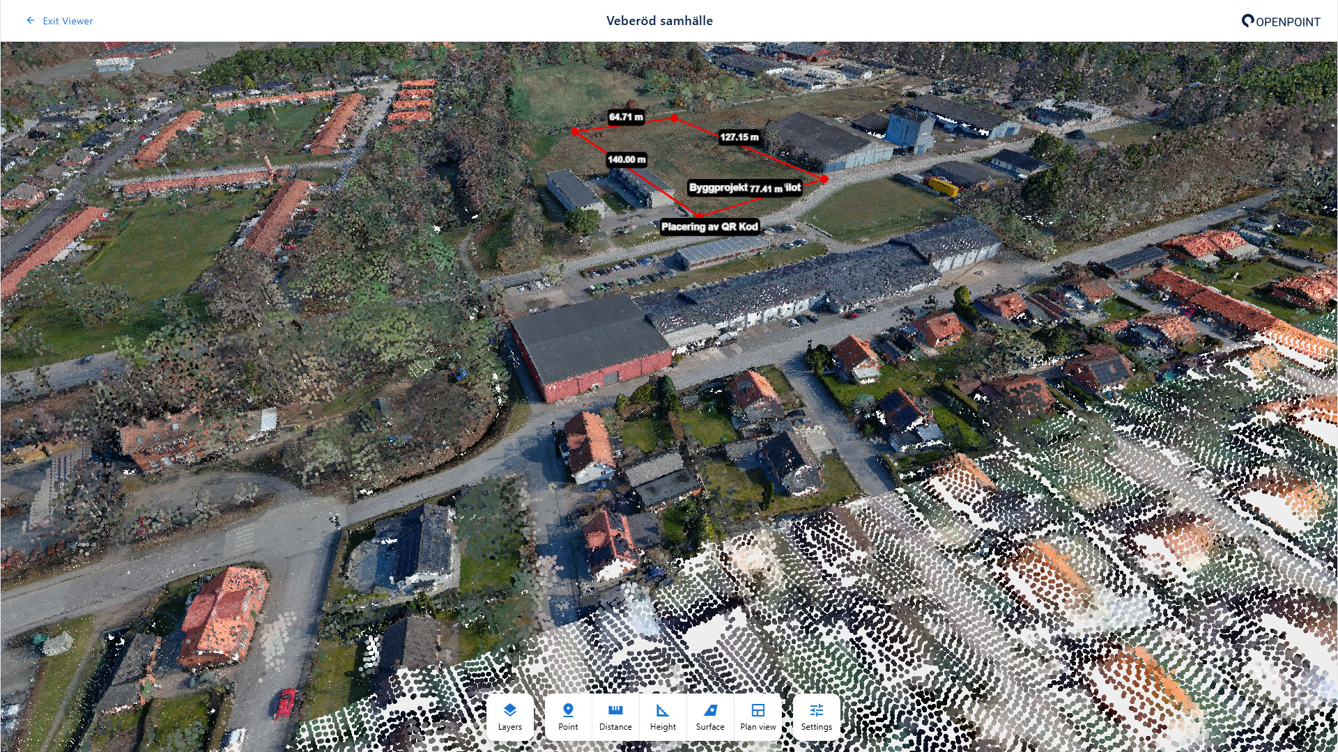
In Veberöd, Smarta Byar has been working for several years with the village's digital twin, which was created by itself and in it made available measurements taken from sensors placed in the village. The digital twin has worked well — though only as an isolated system, not in conjunction with other systems. However, Veberöd's way of engaging with citizens in the process has become interesting for Openpoint, and therefore it is hoped, among other things, to test building permit management together with them.
- It is part of our plans to have a construction project in Veberöd where we can test the building permit process, says Mats Eliasson at Openpoint. We intend that it will be a good complement to normal working methods by being able to create visual coherence.
There are also other opportunities for cooperation with Smart Villages.
- In Veberöd, for example, a noise measurement is carried out on the initiative of the village, explains Robbin Hellström. The new thing is that the measurement could be divided by Swedish Transport Administration and the municipality of Lund via the platform so that no new measurements have to be made. The digital twin is like an operating system where you can add your own measurements, and more.
Smart Villages has also been exploring how to have a civic dialogue for a few years now. Smart Villages have discussions with citizens, including about digitization in their social channels. Recently, Veberödsfolk were asked about their attitude towards image sensors and AI. (Read more)
Openpoint works with municipalities and villages throughout Sweden. Why is it interesting to work with Veberöd?
- I think Veberöd is the initiative in Sweden that has come the furthest in allowing ordinary people to pursue issues, concludes Robbin Hellström. There are others who are conducting a dialogue but Veberöd is technically at the forefront. Veberöd can help set the model for how to do things in municipal Sweden.